Flood alleviation schemes
In Hull, one of the biggest challenges we face is having enough space to store water during heavy or prolonged rainfall, and then moving water through and out of the city. Due to the low-lying nature of the city, water cannot naturally drain. It must be pumped out. Flood risk is managed in a variety of ways by the risk management authorities responsible. These include -
- aboveground structures
- underground structures
- sewers and pumping stations
- nature-based solutions
- sustainable drainage systems
Aboveground structures

Tidal surge barrier. It reduces the risk of a tidal storm surge from coming up the River Hull from the Humber Estuary.
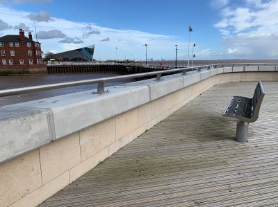
Humber Hull Frontages - reducing the risk of a tidal storm surge from coming up the Humber Estuary.
River Hull defences reduces the risk of fluvial or river flooding from the River Hull. These are potentially caused by increased flows coming from upstream.
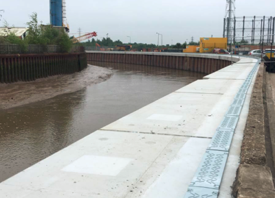
Underground structures
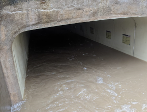
Culverts - moving water underground in pipes from one location to another.
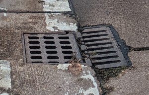
Gullies - taking water from highways and roads to reduce flood risk of surface water flooding.
Sewers and pumping stations
The sewers transport foul waste and surface water to east Hull wastewater treatment works. The pumping stations help the water move through the sewers. It is discharged into the Humber Estuary.
Sewers
Moving surface and wastewater underground to wastewater treatment works before being discharged into the Humber.
Bransholme Pumping Station
A surface water storage site and pumping station with the largest Archimedes screw pumps in Europe. It reduces the risk of sewer and surface water flooding in North Hull. This is done by delivering water from the storm sewer network to the River Hull.
Construction began in 2014 and was completed in 2016.
Holderness Drain Pumping Station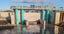
4 pumps installed to reduce the risk of fluvial or river flooding from the Holderness Drain. This is done by pumping water from the drain out into the Humber Estuary during high tide. This pumping station was built as a part of the Holderness Drain Flood Alleviation Scheme (FAS).
Nature-based solutions
Through the AquaGreen Flood Alleviation Scheme, we have implemented nature-based solutions to managing flood risk. This is done with Surface Water Storage areas. They fill during heavy or prolonged rainfall. This can reduce the risk of flooding as it slows the flow of surface water into the drainage system.
Another benefit of this is that it also improves our community green spaces. By giving space back to nature, we make more space for water.
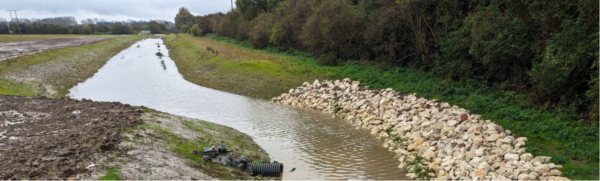
Rock Armour at Sutton Cross Drain.
Mitigation
Flood alleviation schemes are designed to reduce the risk of a certain type of flooding to a certain design standard. Some structures can reduce the risk from more than one source of flooding.
For example, the River Hull defences reduce the risk of river or fluvial flooding. It has a standard of protection for one in 200/0.005 annual exceedance probability flood event. These types of flood defence do not reduce the risk of surface water, sewer, or groundwater flooding.
There are schemes all over the city acting to reduce the risk of flooding. For more information on the types of schemes above, access the Drainage asset map or Appendix 6 of the Local Flood Risk Management Strategy. Not all risk can be managed by schemes alone. This is why we are committed to community engagement and research as tools to become more flood resilient.
Funding
The UK government has committed to spending £5.2 million on flood risk management between 2021 and 2027 in England. The main aim of a flood and coastal scheme is to reduce the risk of flooding to communities and businesses. There are also economic, social, and environmental benefits of investing in flood adaptation and resilience schemes.
Partnership working is important in gaining extra funding and delivering projects that deliver multiple benefits.
We would like to thank the following funders for investing. These include, but are not limited to -
- Environment Agency
- Yorkshire Water
- Hull and East Riding Catchment Partnership
- Humber Local Enterprise Partnership
- East Riding of Yorkshire Council
- Yorkshire Wildlife Trust
- and Highways England
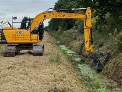
Maintenance of flood infrastructure
Maintenance of flood risk assets is important to make sure that the assets are performing as they should to keep the flow of water moving, or to hold water in locations where minimal damage will occur. If assets are not maintained, then they are likely to deteriorate into a state of disrepair. This would lead to costly replacements. Each RMA has maintenance programmes for the assets they are responsible for.
We are responsible for -
- ordinary watercourses in the city where the council is the riparian owner
- assets that HCC have entered an agreement with other RMAs
- sections of main rivers that HCC have culverted
A rolling maintenance schedule is used to maintain our flood risk assets, including -
- watercourses and other assets, including trash screens, are monitored regularly. This can be done by site visits and CCTV or telemetry alerts
- vegetation along watercourse banks is maintained as and when required. For example, if the vegetation is causing a flood risk, or if it is blocking access to an asset. This is to allow the natural environment to thrive and promote biodiversity
- where practical, after vegetation has been cut back, wildflower seeds are planted along the top of the riverbanks. This is to promote a thriving area for wildlife
- watercourse works are planned to avoid bird-nesting season to minimise the disruption to established habitats. Where possible, an area of refugee is left for animals
As well as the rolling maintenance programme, more maintenance is carried out if -
- a weather warning is issued. Trash screens are inspected to make sure there are no blockages preventing water from being conveyed through the drainage system
- a telemetry alarm is triggered. It alerts us to higher-than-normal water levels in a watercourse
- an incident of fly tipping is reported within our managed watercourses that poses a flood risk
Our Local Flood Risk Management Strategy provides more information on how we are managing flood risk in the city.